Saturday, September 7, 2013

9/7/2013 9:00 am: fire update


Last update unless significant fire activity occurs 

Saturday, September 7 to End of Season, 2013 – 9:00 a.m. 

Yellowstone 
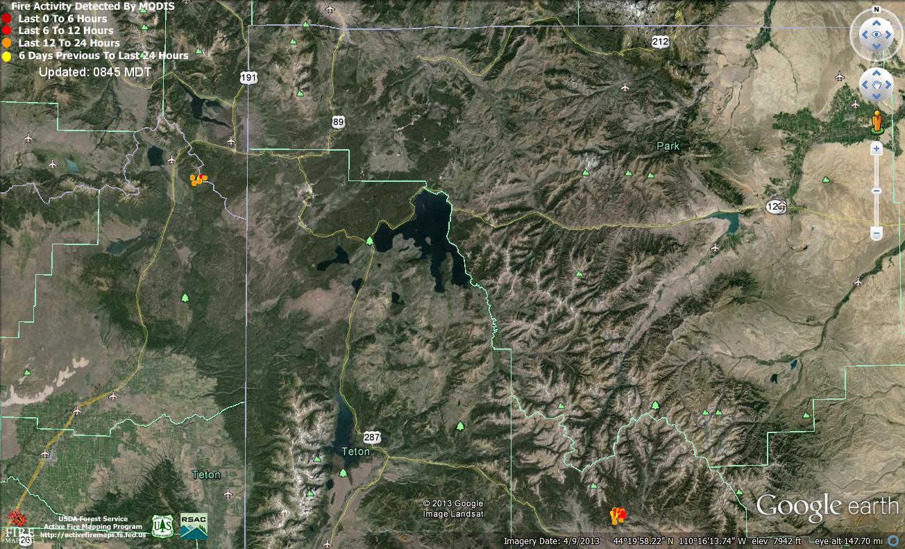
National Park currently has six active fires burning.  The Druid Fire in the northeast near Lamar, the Alum and Calderon near the Fishing Bridge, the Alder Fire on the Promontory at the south end of Yellowstone Lake, and the Snake and Passage Fires near the south boundary of the Park.  All of these fires are being managed jointly as the Druid Complex. 

The Alum Fire is still smoldering in close proximity to the Grand Loop Road corridor between the Mud Volcano site and the Fishing Bridge.  Small amounts of smoke from the fire are visible intermittently from the Mud Volcano area.  All these fires will likely continue to smolder in the down fuels until a season ending event involving significant rain or snowfall.  For public safety, the Park/Incident are maintaining the closure of the west-side highway pullouts designated by orange cones between Nez Perce Ford and LeHardy’s Rapids. 

Fire activity remains light on all fires with visible smoke also being reported on the Alder and Druid fires.  The campsites on the west-side of Promontory Point have been cleared of charred snags but the general area still has potential fire activity and will remain closed.  The campsites (5L8, 5L9) on the northeast portion of Promontory point were opened yesterday. 

An aerial reconnaissance flight planned for yesterday was postponed due to weather and is being planned for late this morning if weather permits.  Still of special concern will be the Druid fire which has smoke visible when traveling easterly on Highway 212 from Tower Junction towards Lamar Ranch.


Additional information can be found on the web at:

www.druidcomplex.blogspot.com - for updates as they become available


Twitter @YellowstoneNPS

Facebook at YellowstoneNPS


Yellowstone National Park Website http://www.nps.gov/yell/index.htm


###


Friday, September 6, 2013

Giving Visitors a New Perspective on the Role of Fire in Yellowstone National Park

Yellowstone National Park hosts visitors from across the United States and all over the world. One can stand by the fire information board at the Mud Volcano area and hear a dozen languages spoken, as children, mothers and dads; grandparents, sweethearts and traveling companions take in the sights --and smells -- of the park’s thermal and geologic features.
Most of these visitors are curious about the current fires described on the fire information board. At this stage of the fire there is little smoke from most of the fires to draw visitors' attention, but sharing a map of the park’s fire history is a perfect opportunity to inform visitors about fire’s role in the natural environment.

Some visitors are very certain that the burned trees they see amid the new growth is a reason to be sad. “I feel so bad,” said one visitor, “because I saw the park before the 1988 fires and it was so beautiful. I wanted my grandchildren to see it like that.” This is an opening that a fire information officer can’t pass up. The right message can turn the sadness to acceptance and understanding.

“Oh, I didn’t know that!” is the recurring response when folks learn that lodgepole pine, which make up a significant percentage of the park’s forests,  can only reproduce when their seeds are released from their cones by the heat of a fire. Many visitors inquire if the dense, young forests they see growing around the black, spindly remnants of previous fires have been planted by park rangers.  They are surprised to learn that the young trees are the same size because they were all born (seeded) from the cones dropped by the parent trees after the same fire. And then they understand that lightning-caused fires are a natural part of the park’s ecosystem.

 For decades forestry experts believed that all fire was bad and suppressed all fires that started in the park. This invited the catastrophic fires of 1988. Now forest ecologists know that Infrequent but high intensity fires cause wide-spread damage and can even sterilize soil for generations.  More frequent, lower intensity fires make the forest a healthy, vibrant and inviting habitat for diverse plants and animals. So now fires are managed to protect visitor safety and park infrastructure (point protection) but otherwise are allowed to play their vital role in the park’s natural environment.

“Do the fires go out by themselves?” many people ask when they find out that firefighters don’t suppress, contain or put out naturally caused fires. Yes and no. The weather changes as we get closer to fall. There is less heat from the sun as it slides south. This means the mid-day burning periods get shorter. Often there are more clouds and short periods of daily rain on parts of the park which also helps keep the fire activity at a lower level. So while fires still need careful monitoring, many will continue to smolder until long after deep snow covers the park roads, hillsides and canyons.


The reward for providing fire information in Yellowstone National Park is the moment when visitors look at the smoke curling from a hillside and smile, seeing it as a promise for the future instead of as a reason for sadness or fear.

9/6/2013 9:00 am: fire update

 
Friday, September 6, 2013 – 9:00 a.m.
 
Today’s weather forecast calls for a gradual warming trend into the weekend where a moist southwest flow will continue with a lesser chance for isolated showers and thunderstorms.  If showers occur, they will likely be very local and brief with either heavy rain or small hail.  Winds on the ridges can be expected to gust in the 15 to 25 mph range as these thunderstorms approach.
Visitors should have mostly good weather for visiting Yellowstone National Park’s vistas and viewing the abundant wildlife into the weekend.  Carry along a light rain jacket for those brief periods of showers, but take caution if lightning becomes active in your area.
The Alum Fire is smoldering in close proximity to the Grand Loop Road corridor between the Mud Volcano site and the Fishing Bridge.  For public safety, the Park/ Incident are maintaining the closure of the west-side highway pullouts designated by orange cones between Nez Perz Ford and LeHardy’s Rapids.
Fire activity was still light on all fires with visible smoke reported on the Alder, Alum, and Druid fires.  The campgrounds on the west-side of Promontory Point have been cleared of charred snags but the general area still has potential fire activity and will remain closed.  The campsites (5L8, 5L9) on the northeast portion of Promontory point are being opened.
Fire managers will be taking an aerial reconnaissance flight late this afternoon to observe fire movement in the past few days.  Of special concern will be the Druid fire which has visible smoke from the highway but no easy access to actually determine any needs or public safety concerns.
Additional information can be found on the web at:
www.druidcomplex.blogspot.com - for updates as they become available
Twitter @YellowstoneNPS
Facebook at YellowstoneNPS
Yellowstone National Park Website http://www.nps.gov/yell/index.htm
###


Thursday, September 5, 2013


Wednesday, September 5, 2013 – 9:00 a.m.

The last several days have brought cool, moist and stable conditions to the Druid Complex in Yellowstone National Park.  Most of the 6 widely scattered fires on the complex, all lightning starts, have benefitted from rains in the afternoon and evening periods as well as early morning fog. The fires have been so subdued that little smoke has been showing and visitors have been enjoying clear visibility with spectacular cloud formations highlighting the park’s classic landscape and wildlife views.

The firefighting force has dropped to 35 as conditions continue to improve.  Firefighters will work today in the Alder fire area on Lake Yellowstone’s Promontory Peninsula. That means good news for late-season campers. They will be clearing three area campgrounds of ‘snags,’ dangerous burned or partially burned trees. When the work is complete the park will be free to set a date to open them to the public.

Crews will be removing the portions of the ‘plumbing’ for sprinklers that were installed earlier when the fire was much more active. On-site inspections will be made on the Alum Fire near the Mud Volcano area to determine the exact position of the fire in relation to Highway 89.

The weather patterns for today are showing scattered showers and lightning storms tracking from the south/southwest in a northeasterly direction.  These storms are moving very quickly and can produce lots of lighting and possibly hail.

Please be safe and return to your vehicle or get inside a building when weather moves in and thunder storms and lightening appear.  If you are caught outdoors, find a low spot away from tall trees and crouch (do not lie) on the ground, making yourself the smallest target possible. 

Additional information can be found on the web at:
www.druidcomplex.blogspot.com - for updates as they become available
Twitter @YellowstoneNPS
Facebook at YellowstoneNPS
Yellowstone National Park Website http://www.nps.gov/yell/index.htm

###

Wednesday, September 4, 2013

Druid Complex 9/4 9 a.m. Fire Update


Wednesday, September 4, 2013 – 9:00 a.m.

Six wildfires smoldering in Yellowstone Park are having no effect on visitors.  Three showed no smoke at all Tuesday.  The most active, the Alum fire, was burning in a few concentrations of heavier fuels and isolated stumps and roots in the ground.  Firefighters continue to monitor these lightning-caused fires as they are a natural part of the ecosystem. Those fires refresh and renew the lodge pole pine forests.

The cooler weather and precipitation the Park has received the past few days has allowed fire managers to down-size the organization for the reduced current and expected fire activity.  Fire managers feel good that the minimal fire activity and recent precipitation are giving some firefighters the opportunity to move on to higher priority fires and others a rest break at home after what has been a long and strenuous season.  These actions will not jeopardize public or firefighter safety.  And if the fire activity again increases, fire managers have access to the national ordering system to increase the fire fighting forces quickly and efficiently.  A total of 58 firefighters were involved in operations yesterday (9/3) and forces will likely be trimmed a little more today.

When the Alum fire was burning strongly to the west in the third week of August, fire managers laid plans to protect developed areas along Yellowstone Lake by preparing a defensible fireline nearby from which to burn out fuels if necessary.  Since then firefighters have cleared a defensible indirect line along much of the power line that runs from the Lake area to Bridge Bay.  Lanes under power lines are kept clear of large trees to prevent electrical transmission problems but firefighters widened this corridor and so far no burning has been needed.  The brush and material hauled out has gone into an area burned by the 2009 Arnica fire, south of Bridge Bay.

Firefighters completed most of that task Tuesday, but are waiting for drier weather so they can remove the mats laid over marshy areas for machinery to work on and not damage any wetlands.

Additional information can be found on the web at:
www.druidcomplex.blogspot.com - for updates as they become available
Twitter @YellowstoneNPS
Facebook at YellowstoneNPS
Yellowstone National Park Website http://www.nps.gov/yell/index.htm

###

Tuesday, September 3, 2013

9/3/13 10:00 am: Druid Complex Tuesday update

Tuesday, September 3, 2013 – 9:00 a.m.

Rain soaked the southern tier of Yellowstone Park Monday midday.  Slow-moving blanket-shaped clouds left about 1/3 inch of rain across the Alum fire, northwest of Fishing Bridge.  That fire had shown more heat Sunday than in the past week.  Now its growth has been slowed for another week or so by Monday’s rain.  Many overlooks and picnic areas reopen during the day Tuesday along Grand Loop Road between Fishing Bridge and the Mud Volcano area.  Only one two-mile “no stopping” section remains between Nez Perce Ford and LeHardy Rapids.

Less precipitation fell in the northern reaches of the park, where the Druid fire soaked up only 1/10 inch.  Still, Tuesday morning saw dense fog about sunrise in low areas, as the ground gives up some of its extravagant moisture.  The Druid is more likely to show smoke in coming days than are the other five lightning fires that have been smoldering in the park.

Rain measurements got confounded for a few hours Monday morning. A bison rubbed and tipped the rain can of the “RAWS” remote access weather station in Hayden Valley.  Firefighters depend on RAWS measurements when they predict fire spread.  A National Weather Service meteorologist assigned to the Druid Complex recalibrated the instrument.  As some rain remains in the forecast, fire behavior analysts saw both sides Monday: “We may be out of the woods, and we may not,” regarding extensive further spread of the Alum fire.  Either way, the Alum fire is refreshing the lodgepole pine forest landscape.

Tuesday should be partly cloudy in the morning, with a stray thunderstorm in the afternoon.  Humidity will stay high at 35% or more, depending on how much sunshine appears.  Wednesday begins a drier trend once more.  126 remaining fire personnel are supporting hand rehabilitation of the indirect fireline that they improved in developed areas near the Grand Loop Road.  Fire staffing goes up and down based on potential fire activity.

Additional information can be found on the web at:
www.druidcomplex.blogspot.com - for updates as they become available
Twitter @YellowstoneNPS
Facebook at YellowstoneNPS
Yellowstone National Park Website http://www.nps.gov/yell/index.htm


###

9/3/13 9:30 am: photos from the incident command post behind Fishing Bridge store

Yellowstone house finch helps information officers

dawn fog veiled morning briefing Tues Sept 3 at 7:00 am

Monday, September 2, 2013

9/1/13 11:15 am: photos of the height of Alum fire activity Sunday

Even when groups of trees torched about 3 pm Sunday, visitors saw mostly smoke from smoldering materials rather than flame.  Although temperatures were high and the air was dry, not enough wind arrived to make the fire grow as it might have:

The Grand Loop Road by LeHardy picnic area, directly under the fire, was clear of smoke at 5:15 pm, at the height of the"burning period" Sunday afternoon, when fire is usually most active:


9/2/13 9:45 am: Rain today, pretty sure - with the chance of up to an inch of rain

FLOOD WATCH
NATIONAL WEATHER SERVICE RIVERTON WY
904 AM MDT MON SEP 2 2013

...FLASH FLOOD WATCH IN EFFECT FROM MONDAY MORNING THROUGH MONDAY
EVENING...

.A RELATIVELY DEEP AND MOIST ATMOSPHERE ASSOCIATED WITH AN UPPER
LEVEL DISTURBANCE MOVING INTO THE WESTERN MOUNTAINS OF WYOMING FROM
THE SOUTHWEST...WILL PRODUCE NUMEROUS SHOWERS WITH EMBEDDED
THUNDERSTORMS ACROSS THE WESTERN MOUNTAINS AND JACKSON VALLEY
THROUGH THIS EVENING. UPPER LEVEL FLOW WILL BE MODEST AT BEST...SO
STORMS WILL MOVE RATHER SLOWLY FROM SOUTH TO NORTH WITH SEVERAL
STORMS TRAINING OVER THE SAME AREAS WHICH MAY PRODUCE FLASH
FLOODING CONDITIONS...ESPECIALLY IN AREAS ABOVE 7500 FEET IN
ELEVATION.  DEBRIS FLOWS ON STEEP SLOPES OF RECENT WILDFIRES...AND
KNOWN SLIDE AREAS SUCH AS SYLVAN PASS HAVE INCREASED FLASH FLOOD
POTENTIAL.

YELLOWSTONE NATIONAL PARK-ABSAROKA MOUNTAINS-
INCLUDING THE CITIES OF...LAKE...MAMMOTH...OLD FAITHFUL
904 AM MDT MON SEP 2 2013

...FLASH FLOOD WATCH IN EFFECT FROM 1 PM MDT THIS AFTERNOON
THROUGH LATE TONIGHT...

THE NATIONAL WEATHER SERVICE IN RIVERTON HAS EXPANDED THE

* FLASH FLOOD WATCH TO INCLUDE A PORTION OF NORTHWEST WYOMING... 
  INCLUDING THE ABSAROKA MOUNTAINS AND YELLOWSTONE NATIONAL PARK. 

* FROM 1 PM MDT THIS AFTERNOON THROUGH LATE TONIGHT

* A LARGE AREA OF SHOWERS AND THUNDERSTORMS WILL MOVE UP FROM 
  UTAH AND SOUTHEAST IDAHO THIS MORNING. SOME AREAS COULD SEE AN 
  INCH OR MORE OF RAIN...ESPECIALLY AT ELEVATIONS OVER 7500 
  FEET. 

* FLASH FLOODING OF SMALL STREAMS WILL BE POSSIBLE AS WELL AS SOME
  AREA ROADS WITH POOR DRAINAGE. FIRE BURN SCARS AND SYLVAN PASS
  WILL BE PRONE TO DEBRIS FLOWS WHILE ROADS THROUGH STEEP CANYONS
  WILL BE SUSCEPTIBLE TO ROCK SLIDES.

PRECAUTIONARY/PREPAREDNESS ACTIONS...

A FLASH FLOOD WATCH MEANS THAT CONDITIONS MAY DEVELOP THAT LEAD
TO FLASH FLOODING. FLASH FLOODING IS A VERY DANGEROUS SITUATION.

YOU SHOULD MONITOR LATER FORECASTS AND BE PREPARED TO TAKE ACTION
SHOULD FLASH FLOOD WARNINGS BE ISSUED.

9/2/13 9 a.m.: Druid Complex Fire Update


Monday, September 2, 2013 – 9:00 a.m.


Of six lightning-caused fires in Yellowstone Park, only one showed widespread activity in Sunday’s dry weather.  Sunday afternoon, the 7097 acre Alum Fire responded to low relative humidity and sunny skies by producing intermittent smoke columns visible from Hayden Valley overlooks and the Mud Volcano area.  A few groups of live trees flared for about a minute each as they torched, sending quick pillars of dark smoke skyward amid whiter smoke from smoldering dead logs and roots on the hillside.  Many holiday visitors shared surprise that they got to view a real Yellowstone wildfire.  From Mud Volcano, the smoke often resembled steam from thermal features.

Despite its show of strength, the Alum Fire lost energy as the sun sank.  Fire managers had expected that the fire might gain enough momentum to reach the Grand Loop Road between Fishing Bridge Junction and the Mud Volcano, and thus might force a tourist-annoying road closure.  However, the fire grew only a few acres, and Labor Day park visitors could complete their routes as they planned. 

Monday, clouds herald a new weather pattern moving into the Yellowstone region.  The new system will bring the region increasing humidity and wind Monday, and the potential for several days of short showers or thunderstorms. 

Many visitors still ask why firefighters are not extinguishing the smokes they see.  Yellowstone is a living laboratory for natural processes, where firefighters try to allow fire to play the role that it did before the park was created in 1872.  Crews suppress all human-caused fires such as from cars or powerlines, but respect the growth of most lightning-caused fires, except when public safety or developed areas are at risk.  In the lodgepole pine forest that covers much of the park, mature trees reseed the landscape when they burn. 

Other fires in the Druid Complex were less active on Sunday.  Those fires include the Druid, Alder, Snake, Passage, and Caldron Fires.  None shows more than an occasional puff of smoke.  Any of these fires may continue to smolder through damp weather and reignite when dry, windy days return.

Additional information can be found on the web at:

www.druidcomplex.blogspot.com - for updates as they become available


Twitter @YellowstoneNPS

Facebook at YellowstoneNPS


Yellowstone National Park Website http://www.nps.gov/yell/index.htm


###

Sunday, September 1, 2013

9/1/13 9:00 pm: Each species of tree has its own responses to wildfire

Each species of tree has its own response to fire.  Fire also burns with different frequencies in different landscapes.  The severity and frequency of wildfires vary depending not just on the weather and on the physical landscape, but on what is burning.

Yellowstone does not have as many species of trees as do forests in moister lowland regions nearer the East Coast or West Coast.  Most of the trees in the park are either lodgepole or whitebark pine, Englemann spruce, or white fir or subalpine fir.

Most of the Alum fire is burning in mature lodgepole pine forest, which is the tree type that burned across the park in 1988.  Lodgepole grows at about 7000 to 8500 feet elevation at this latitude.  About half of lodgepole pine trees have a unique relationship with fire:  they depend on wildfire in order to reproduce. Their serotinous pine cones, covered in gummy resin, cannot open without being heated, either by a hot summer day, or by fire, or by about 15 seconds in a microwave oven.  After exposure to heat, the sealed bracts or scales of the mature cones peel apart so the tiny winged seeds can emerge.  The cones stay viable (with live seeds) for six to eight years on the trees, just waiting for a fire to open them.  In other words, lodgepoles usually produce seedlings when the parents burn.

Thus because the lifetime of a lodgepole pine tree is about 200 or 250 years, fire usually burns through the crowns (treetops) of older, weaker lodgepole pine forests only about every 150 to 200 years.  Adult lodgepoles lose their lower branches, so in mild weather, lodgepole trees do not burn.  Only their fallen needles burn along with underbrush.  The physical design of lodgepole crowns is an open ladder that can carry fire from lower to topmost branches within seconds.  In dry enough, windy enough weather, lodgepole fires race across treetops, releasing fresh seeds to repopulate the landscape as the older trees turn to ash.

Whitebark pine trees, in contrast, live in extreme high mountain areas up to 12,000 feet.  Their large pine nuts are a favored food of grizzly bears.  Clark's nutcrackers have a symbiotic relationship with the wihitebark pines and plant new stands of trees by caching the seeds.  On their cool, moist mountainsides, whitebark pines have a short fire season and are used to small, irregular fires that burn only a few drier trees.

Spruce trees, like whitebarks, are vulnerable to fire due to their thin bark, but usually avoid fire by growing in high moist mountain environments.  They like to grow in shade.  Shade-loving Douglas fir trees have thick platy bark, so they survive many low-intensity fires. High on the mountainside overlooking the Lamar valley, the Druid Fire is burning in heavy spruce-fir forest.  Spruce-fir fires usually do not kill every tree, but burn instead in a raggedy patchwork or mosaic of burned areas.  Fir trees throw lots of sparks as they burn, so they often send small fires burning in spots ahead of the rest of a fire.  After a wildfire in these forests, first herbaceous plants like fireweed and ceanothus brush must grow to provide shade for seedling trees.  Decades can pass until existing seeds in the soil regenerate enough to provide a new tree canopy.

9/1/13 10:10 am: Check "What Happens When"

We added a new page to the blog: "What Happens When."
The link is also above the map above, to the left.

So far we have talked on that page about
--  what happens to wildlife in a Yellowstone fire,
--  what happens to a fire when it rains,
--  what happens if or when firefighters leave, and
--  what happens as the land recuperates.

Please comment or email us at yellowstone.fire.info@gmail.com to let us know more discussion and topics that you would like to see on this page!

9/1/13 8:45 am: Google Earth satellite image of Sunday morning fires near Yellowstone Park


This morning's data map above shows two active fires anywhere near Yellowstone National Park.  Our fires within the park were NOT active enough in the last six days to show up on this map.  This morning only small wisps of smoke are coming from our most active fire, the Alum fire.  Skies are clear and beautiful.

Two Earth Observation System scientific satellites, launched in 1999 and 2002, carry instruments called a MODIS (moderate-resolution imaging spectroradiometer) that detect unusual sources of heat on the earth's surface.  Programmer have refined that data to use it to detect fire spread.  The two satellites together deliver fresh data every few hours that show wildfire spread, accurate to within two miles or so.  This data is NOT used to make tactical decisions.  You can download a file that uses Google Earth to show this almost real-time estimate of fire growth for United States locations: click on "current fire detections" at http://activefiremaps.fs.fed.us/googleearth.php .

The Burrough Fire, southeast of Yellowstone Park on the Shoshone National Forest in Wyoming, grew to 1,000 acres and prompted evacuations, while the Two Top Fire, west of the park outside West Yellowstone, Montana, increased to 130 acres.  Activity was minimal on all the other fires in the Greater Yellowstone ecosystem.  Our fires are all quite small compared to California's Rim Fire, which has topped 222,000 acres. 

9/1/13 8:30 am: Morning Update

                                                                                                                  
Sunday, September 1, 2013 – 9:00 a.m.

Fire is a natural process that creates the park landscape.  Two-thirds of Yellowstone’s 2.2 million acres have burned since 1880.  Lodgepole pine trees, the most abundant trees in the park, depend on fire to regenerate.  Fire is not an enemy of the forest, but plays a welcome role when occurring on a natural cycle.  The park sees about 65 fires in an average year, and 90% are lightning caused.  Firefighters manage lightning fires in Yellowstone to protect people and developed areas, but often do not control fires.  Many fires stay small, but hot, dry, and windy weather promotes the spread of wildfire.

Near the Mud Volcano area, the Alum Fire (pronounced AL-umm) woke up Saturday following about ten days of dormancy.  The fire, resurrected by abundant sunshine and low relative humidity, had single trees and groups of trees burning on both the north and east flanks.  Saturday’s sunny and dry weather will prevail Sunday, with even lower relative humidity.  Firefighters may see greater activity in the fire.  Still, fire in Yellowstone Park represents only a fascinating facet of nature:  not a threat, just a possible inconvenience.

The closest road corridor to the Alum fire is the Grand Loop Road between Canyon and Fishing Bridge. Sunday, the fire may approach Grand Loop Road in the afternoon.  If smoke or fire renders the corridor unsafe, that section may require pilot cars or a temporary road closure. The detour for travel would be via Old Faithful, about a three-hour (85-mile) drive.  Traffic would be redirected using electronic signs and park personnel posted at key intersections. These measures would be taken purely to enhance public safety.  If the fire does not come near, the road will remain open.  Notice of any changes is posted on the park’s travel information line:  307-344-2117.

The Caldron Fire, started by lightning last Thursday east of the Yellowstone River near Mud Volcano, was not showing smoke today.  The Druid and Alder fires showed some smoke but did not grow.

Additional information can be found on the web at:
www.druidcomplex.blogspot.com - for updates as they become available
Twitter @YellowstoneNPS
Facebook at YellowstoneNPS
Yellowstone National Park Website http://www.nps.gov/yell/index.htm


###